


Portulin - Belderrig

heb
Utilisateur


8h31
Difficulté : Moyen

Application GPS de randonnée GRATUITE
 SityTrail
IGN / Instituts géographiques
SityTrail World
Le monde est à vous
À propos
Randonnée Marche de 25 km à découvrir à Inconnu, County Mayo, Westport-Belmullet Municipal District. Cette randonnée est proposée par heb.
Description
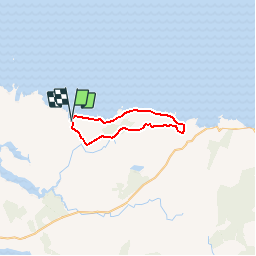
Walk Belderrig-Portulin loop on the North Mayo Cliffs (27km ~ 7 hours)
Belderrig to Porturlin is a stunning cliff walk. It’s a strenuous 14.6km long walk and takes 4 hours and 40 mins.
The trail has its actual start at a T-junction on the Ballycastle-Glenamoy road, south of Belderrig Harbour and finishes at Porturlin Harbour. Soon a diversion leads to a Neolithic Farm Site, a visit is recommended. Then the track continues on the right and reaches a view point at 196m. From here walkers enjoy an excellent view of the coastline. Between Benwee Geevraun and Glinsc a spectacular gash comes into sight. Here the soft igneous rock has been eroded by wave action. At Glinsc, a signal tower, built by the English in 1806, stands. It is located at 270m above sea level on the hill. The walk follows the cliff from Sceilp on to Pollach and reaches the little village of Taobh Mor. Here it bears first south and, after a T-junction, it turns right. Porturlin old school can be seen. Another T-juncton comes into view, here the track turn right and continues on to Porturlin Harbour.
DID YOU KNOW?
BELDERRIG NEOLITHIC FARM SITE
Belderrig Neolithic Farm Site was excavated in 1971 and revealed two different sites, one belonging to the Neolithic Era (3000 years BC) and the other belonging to the Bronze Age (1500 years BC). Pre-bog field systems, equals to Ceide Fields’ ones and delimited by stone walls, were found. A block of pine tree, found here, has been dated by the radiocarbon method to around 2900 BC. Some potteries, flints and a polished stone axe-head were uncovered confirming the radiocarbon data and can be compared with finds from other Neolithic sites in Ireland. The early farmers were forced to abandon the site by a slow changing environment beyond their control. The vast area of bogland started to grow forming a soft blanket. About 1500 BC some Bronze Age farmers moved back to the Belderrig Site and used some stone from the original walls to build new enclosures. A circular house was found; its size suggested it wasn’t a residence, but some saddle querns used for grinning corn seems to confirm it was a granary. A block of burnt wood discovered into the house gave the date to 1500 BC confirming the house was built in the Bronze Age.
SIGNAL TOWER
Signal Towers were built between 1801 and 1806 in response to landings by the French in Ireland. They played a central rule during the Napoleonic Wars (1803-1815) as stations of an early-19th-century communication and alert system along the coast. They were sited in remote locations and each station was visible to its counterparts on either side. These square shaped buildings had two storeys, a flat roof and fireplaces. A wooden ladder led to the main door usually built at first floor level. The signals included a large rectangular flag, a smaller blue pendant and four black balls in various combinations. The towers also communicated with ships. The towers were abandoned after Napoleon’s defeat at Waterloo in 1815.


Localisation
Commentaires
Randonnées à proximité